


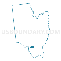
Voting District 030004, Saratoga County, New York
About
Outline

Summary
| Unique Area Identifier | 636433 |
| Name | Voting District 030004 |
| County | Saratoga County |
| State | New York |
| Area (square miles) | 3.26 |
| Land Area (square miles) | 3.24 |
| Water Area (square miles) | 0.01 |
| % of Land Area | 99.57 |
| % of Water Area | 0.43 |
| Latitude of the Internal Point | 42.89754380 |
| Longtitude of the Internal Point | -73.84156220 |
Maps

Graphs
Select a template below for downloading or customizing gragh for Voting District 030004, Saratoga County, New York


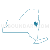
Neighbors
Neighoring Voting District (by Name) Neighboring Voting District on the Map
- Voting District 030001, Saratoga County, NY
- Voting District 030005, Saratoga County, NY
- Voting District 030006, Saratoga County, NY
- Voting District 030012, Saratoga County, NY
- Voting District 030027, Saratoga County, NY
- Voting District 030028 030033, Saratoga County, NY
Top 10 Neighboring County Subdivision (by Population) Neighboring County Subdivision on the Map
Top 10 Neighboring Unified School District (by Population) Neighboring Unified School District on the Map
- Shenendehowa Central School District, NY (62,406)
- Burnt Hills-Ballston Lake Central School District, NY (18,789)